Biocultural Mapping and Ecosystem Modelling
Project description
Preserving and enhancing the conditions necessary for life on Earth is the defining
challenge for inter-disciplinary and trans-epistemic knowledge today. With the majority of
global biodiversity inhabiting the subtropics – and with an astounding 80% of the world’ s remaining
biodiversity harbored within territories governed and conserved by Indigenous peoples – the protection
of Neotropical forests, and the revitalization of Indigenous biocultural knowledges, must undoubtedly be
approached in conjunction to mitigate species loss. This calls for innovative collaborations that weave
broad-scale thinking about global forces with locally-grounded analyses and biocultural conservation
strategies.
Biocultural approaches to biodiversity conservation make evident the interdependence of the
cultural-linguistic diversity of Indigenous communities and the biological diversity within their territories. Academia
therefore plays a pivotal role in supporting Indigenous peoples’ efforts to defend their territories and
mitigate ecological degradation therein. However, defining biocultural conservation targets is
particularly challenging in regions undergoing rapid ecological degradation. Our multidisciplinary team responds to this challenge by collaborating with Indigenous partner communities to identify, monitor, model, and
assess locally defined conservation criteria and indicators.
This project is being carried out with the Centre for Indigenous Conservation and Development Alternatives (CICADA) and the Majé Emberá Drüa community. Our ultimate goal is to integrate Indigenous biocultural knowledge practices, counter-cartographic and videographic techniques with remote sensing, species distribution and hydrological modeling, to develop local ecosystem baselines that will help our partner community, the Majé Emberá Drüa, identify and monitor their forestrecovery targets in the Bayano-Majecito watershed of south-eastern Panama.
So far, this project has produced several tangible outputs that directly support the Majé Emberá Drüa community's territorial governance:
- Co-produced GIS layers documenting both historical changes within the territory (inundation, deforestation, fires) and community-based plans for future projects (reforestation, new schools, tourist sites and paths). These layers have been compiled into comprehensive maps (see Figure) that serve as both planning tools and documentation for the community's land claim process.
- Georeferenced dataset of biocultural keystone species within the territory , generated from extensive transect surveys conducted by community knowledge keepers. This dataset provides unprecedented documentation of the territory's ecological diversity through an Indigenous lens.
- Integrated species distribution analysis that combines traditional ecological knowledge with scientific modeling to inform restoration planning. This analysis helps identify areas of highest priority for reforestation based on both scientific predictions and cultural significance.
- Knowledge exchange infrastructure through training sessions and participatory research methodologies that strengthen intergenerational knowledge transmission while building community capacity to utilize contemporary mapping and modeling tools.
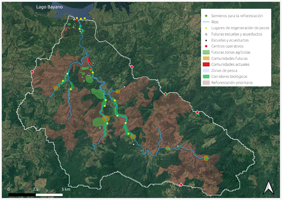
Figure: Map of GIS layers delineated under the guidance of community leaders Mauricio and Lazaro Mecha at the PRISM workshop, November 2024. Printouts of this map were distributed to community members.
PRISM project leaders: Carmen Umaña-Kinitzki, Shriram Varadarajan
Collaborators: Mauricio Mecha (Emberá community leader), Lazaro Mecha (Emberá community leader)
Publications: To follow